Moving Mountains
An exhibit shows that sparse information once led to cartographic creativity.
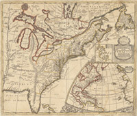
Take a close look at this 1719 map of the English empire in America. Notice something a little strange about the topography?

English cartographer John Senex took some creative liberties when he decided to insert an imaginary mountain range stretching from Michigan to Florida. Courtesy UW Sea Grant Institute.
English cartographer John Senex took some creative liberties when he decided to insert an imaginary mountain range stretching from Michigan to Florida, connecting it to the Appalachians. It was the sort of tactic mapmakers of the time often employed when there was little or no information available about an area.
Senex’s map is included in Making Maps, Mapping History, an online exhibit organized in part by the UW’s Sea Grant Institute that illustrates three hundred years of mapmaking in Wisconsin and the Great Lakes region.
The fantastical mountain range may not be entirely Senex’s fault: he based the map on information about the Great Lakes and Canada provided by various Jesuit and French sources. But the error persisted long after Senex died in 1740, showing up on maps well into the nineteenth century. They became valuable collector’s items, along with Senex-drawn maps that show California as an island.
Published in the Spring 2011 issue

Comments
No comments posted yet.