Map Quest
Aerial lasers inspired Chris Fisher to lead an expedition — and to change his view of archaeology.
This is not an adventure story.
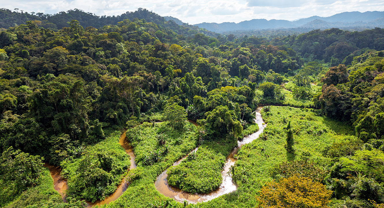
It would be easy to make it one. The discovery of the City of the Jaguar is a tale rife with adventure: a site lost to human knowledge for five centuries, a jungle that is impenetrable (or nearly so), mysterious legends, brushes with death, deified monkeys, temples, idols, helicopters, and poisonous snakes.
But this is not an adventure story because it’s the story of Chris Fisher MA’95, PhD’00. “Adventuring doesn’t interest me at all,” he says. “People going off in the jungle and trying to find this place and coming back with tales of cities with monkey-god statues and all kinds of crazy stuff — that side of it just bores me to tears, honestly.”
Fisher, an archaeologist with Colorado State University, was the lead researcher on the expedition to the rain forest of the Mosquitia region in Honduras. He found, documented, and named the City of the Jaguar in 2015. He then returned and excavated a small portion of the site in 2016.
The city was built by a poorly documented culture that existed on the frontier between the better-known Mesoamerican cultures (such as Maya and Aztec) and the Isthmo-Colombian civilizations of Panama and the north end of South America. The city supported tens of thousands of residents with a complex system of irrigation and agriculture. Then the Spanish arrived, and with them European diseases. In the early 1500s, the City of the Jaguar suffered a population collapse. The area was abandoned, and the jungle reclaimed the ruins. Few humans, if any, visited the site for nearly 500 years.
But the story of the City of the Jaguar is about more than history. It’s also a story of a new technology called LiDAR and its increasing role in archaeology. An acronym for light detection and ranging, LiDAR uses lasers much in the same way that sonar uses sound: by reflecting many thousands of light beams off a surface, it can create a highly accurate, three-dimensional topographic map. Using airborne lasers, an archaeologist can survey many square kilometers of territory to see signs of human habitation. Though not all archaeologists accept the results of LiDAR surveys, Fisher has become an advocate.
“LiDAR has been transformative to my career in ways that I couldn’t possibly have imagined,” he says. “This is a paradise for archaeology. I can’t help but pursue that line of inquiry for the remainder of my career.”
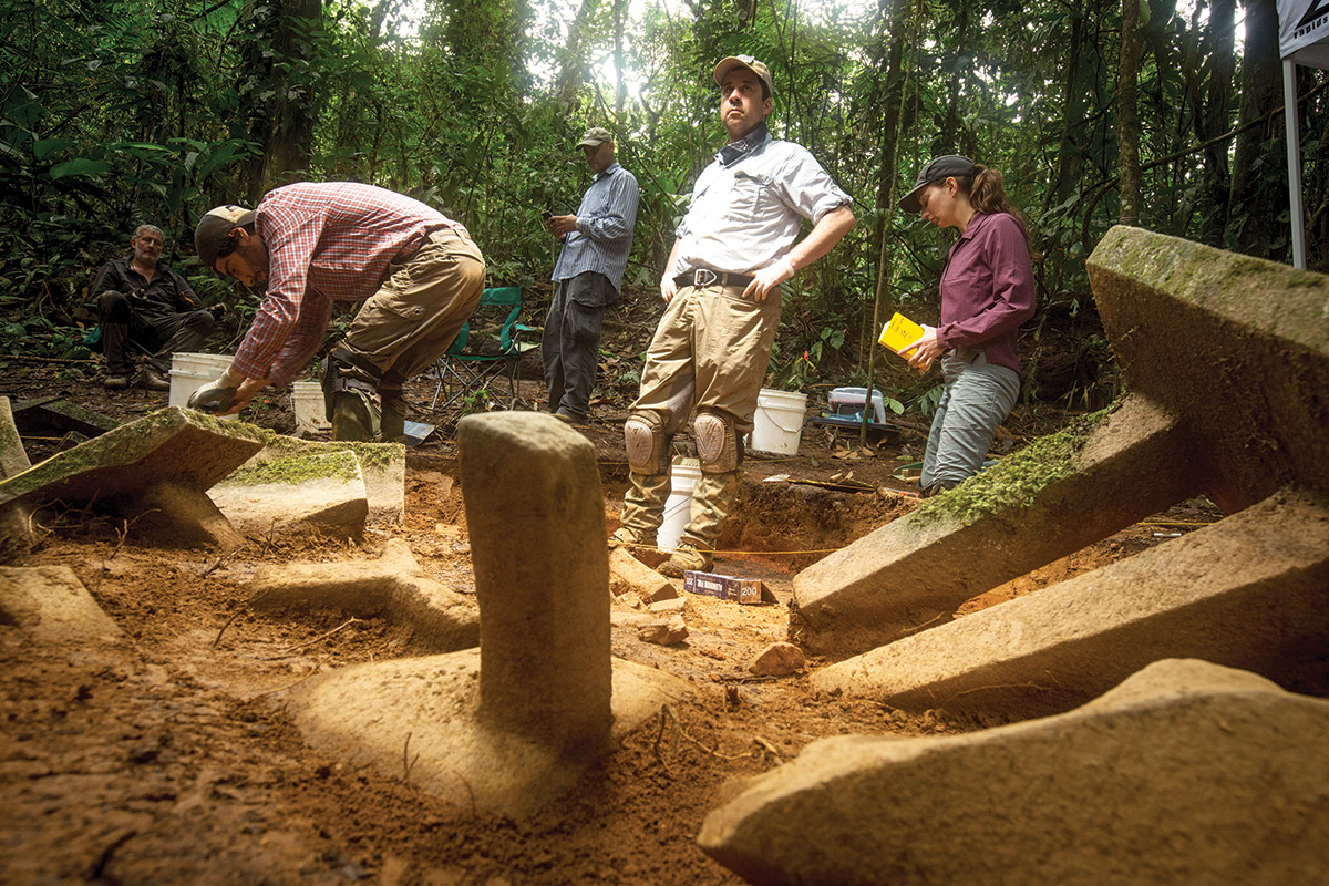
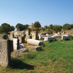
Chris Fisher (center) stands amid the ruins of the City of the Jaguar. These carved stone artifacts (called metates) were seen on a laser survey of the region.
• • •
LiDAR is a recent passion for Fisher. When he was a graduate student at UW–Madison, he trained in boots-on-the-ground methods of digging and classifying artifacts and evidence. He specialized in studying the Tarascan people, Mesoamerican neighbors of the Aztecs before the arrival of the conquistadores. At the UW, Fisher studied with anthropology professor Gary Feinman and wrote his dissertation about work in western Mexico around Lake Pátzcuaro, in the state of Michoacán de Ocampo. He’s returned there regularly ever since to excavate the ruins of a city that he helped to discover, a city he calls Angamuco. It’s his true passion, and his connection there is much stronger than at the City of the Jaguar.
For his dissertation, “Landscapes of the Lake Pátzcuaro Basin,” Fisher challenged orthodox thinking. The standard view on early urban populations was that cities grew until they became too great a strain on their local environment; when that happened, it caused an ecological crisis, and then the cities fell. Many archaeologists believed that the cities of Mesoamerica were on the verge of environmental collapse before the arrival of Columbus. The influential archaeologist Sylvanus Morley, for example, wrote that “the Maya collapsed because they overshot their carrying capacity. They exhausted their resource base, began to die of starvation and thirst, and fled their cities en masse.”
Fisher suggested that this was backward: that more people meant more labor to maintain environmental stability, and that it was rapid population loss that led to environmental disaster.
“People need the labor from that population to be invested in the landscape so that it’s more productive, more stable,” he says. “When you pull the population out, then that created landscape, which is dependent on human labor, ends up falling apart. It ends up being an environmental catastrophe. And that’s exactly what happens at the time of European contact. You see decimated Native American populations. People weren’t able to maintain this landscape, and it eroded away and melted away.”
Fisher returns to Lake Pátzcuaro virtually every academic season, excavating with a team of a dozen students. That group can work through about a square kilometer each year that they work there, but Angamuco covers some 26 square kilometers.
“You’re looking at a career, just to map and understand one place,” Fisher says. “If I were still in grad school, or if this was a decade ago, that might be acceptable. But I’m pretty impatient.”
It was impatience — and the influence of Stephen Leisz MS’96 — that connected Fisher with a new way to map the lost city.
• • •
Though Leisz, too, is a member of Colorado State’s anthropology department, he’s not an archaeologist, nor a specialist in pre-Columbian America. He’s a geographer. A product of the UW’s Nelson Institute for Environmental Studies, he focuses on modern land use, particularly in Southeast Asia, and how this affects global warming.
“My interest is really not just in changing patterns of land use and land cover, but what are the drivers of that change?” he says. “And that ties in to climate change, because when you look at land cover, you’re looking at the level of carbon sequestration on the landscape.”
Leisz’s work requires him to look at large swathes of land all at once, and so much of what he does is dependent on remote viewing: satellite and aerial photos. This led him to discover LiDAR — a tool that wasn’t of great use in his work, as the data it generates are too finely detailed, but which he realized could be a great boon to an archaeologist.
A LiDAR scan, Leisz notes, can create three-dimensional images — not merely a view of the ground, but the height of every surface. Further, it can generate thousands of laser returns per square meter of ground, coverage so dense that it can see through thick vegetation and produce maps as clear as if there were no plants. By filtering out the returns from tree and bush height, LiDAR technicians could get 20 to 25 returns per square meter of ground.
“We could see through forest canopy,” Leisz says. “We could make a high-resolution map of the ground.”
Leisz told Fisher about the technology, and the two convinced the Denver engineering firm Merrick to make a scan of Angamuco. They were able to map nine square kilometers in a single flight. They documented terraces, pyramids, and the foundations of buildings — nearly a decade’s worth of work on the ground.
From that effort, Leisz authored a chapter (“An Overview of the Application of Remote Sensing to Archaeology during the Twentieth Century”) for the textbook Mapping Archaeological Landscapes from Space.
In the meantime, documentary filmmaker Steve Elkins, who was preparing for an expedition to Honduras, was also thinking about LiDAR, and he was intrigued by the work Fisher had been doing.

This LiDAR scan shows what exists beneath the jungle. The aerial laser generated an image that shows raised mounds and flattened plazas and even suggests where artifacts lie (the small white spots). Courtesy of Chris Fisher
• • •
The Elkins connection begins with an adventurer — one of Fisher’s least favorite opportunists.
Theodore Morde was a radio reporter, sometime diplomat, and occasional explorer when he went off to the Mosquitia jungle in Honduras in 1940. When he emerged four months later, he fired off a story for the New York Times. “ ‘City of the Monkey God’ is believed located,” read the headline on July 12.
Morde offered artifacts and rumors of gold, silver, oil, and platinum. To spice the story further, he added lurid stories of human sacrifice, monkey-human hybrids, and a temple that could easily have graced King Kong’s hometown.
“The lost City of the Monkey God thing is crazy,” Fisher says. “It’s fraudulent. I hate dealing with it.”
But Elkins was interested in Morde’s story, or at least in how it connected with Honduran legends of a place called Ciudad Blanca — a “white city” lost in the jungle.
Ciudad Blanca is the Mosquitia’s version of El Dorado — a place of vast wealth that the conquistadores had heard accounts of but had never quite been able to locate. Explorers had speculated about it for centuries, and occasional reports kept the legend alive. Charles Lindbergh x’24 was one of the rumor mongers — in 1927, he claimed to have seen its ruins while flying over Honduras. Morde happily wrapped those rumors into his claims about the City of the Monkey God.
Elkins and his partner Bill Benenson wanted to find out if Ciudad Blanca existed, so they funded a flight over the Mosquitia to create a LiDAR map. They then approached Fisher and Leisz to interpret their data.
“He came out here to Colorado, and my team could instantly look at the data and say, yeah, there’s a city here, and there’s another city,” Fisher says. “You’ve got hundreds of other features here, terraces and landscaping.”
Elkins and Benenson then helped to outfit Fisher for an expedition to do what Fisher calls ground-truthing: to go to the site and manually document what the scans showed — to prove that the lost Honduran city existed. The knock on LiDAR, among traditional archaeologists, is that the technicians who look at scans are imagining order out of random returns, like seeing shapes in clouds. Until an expedition confirms the facts on the ground, a scan holds little sway.
“So out of Morde’s fraud,” Fisher notes, “we actually got some real archaeology done.”
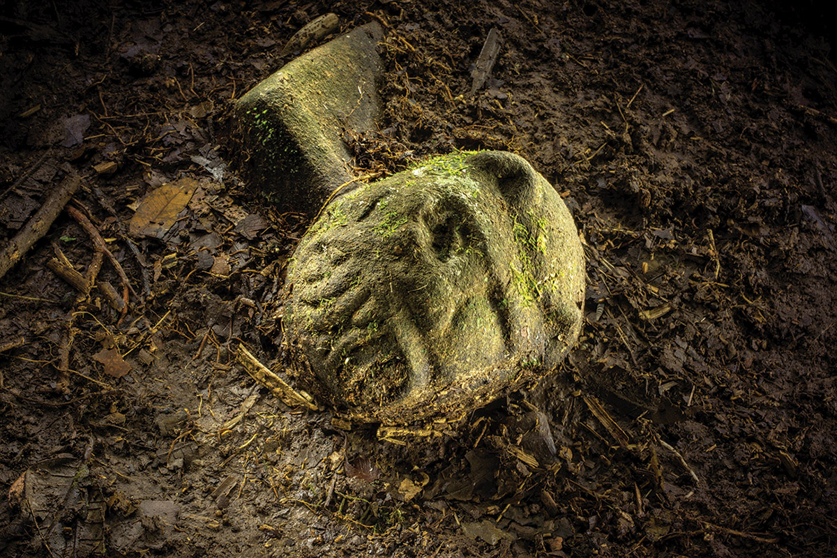
Fisher named the site after the werejaguar figurine shown here. He suspects that it might represent a shaman figure leaping into the form of a spirit animal.
• • •
Then began Fisher’s experience with adventuring. He and his colleagues had to penetrate a trackless forest: this region of the Mosquitia has no roads or paths or settlements. Flown in by Honduran military helicopters that are U.S. Army surplus from the Vietnam War, Fisher and his team had to cut their way to the site that the LiDAR scans had shown them.
“We were dropped into this place, and it’s the only place I’ve ever been in my life where there was no evidence of people having been there,” he says. “There’s no plastic. There’s no garbage. There’s no trails. The animals aren’t afraid of people.”
But the people were afraid of the animals. The Mosquitia is home to several species of poisonous snakes, as well as jaguars, crocodiles, and bullet ants. The nonanimal threats, Fisher would learn, were even worse. During the expedition, he and most of his teammates were bitten by sand flies and contracted a parasitic protozoan — one carrying a form of the disease leishmaniasis. This, too, was a discovery of a sort, as this particular species of Leishmania protozoan had never been documented. Leishmaniasis causes open sores and decaying flesh. For treatment, Fisher had to undergo a process similar to chemotherapy over several weeks at the National Institutes of Health in Washington, DC.
“They actually cultured the variety that we got from my lesion,” says Fisher. “I’m trying to get them to name it after me, to call it Leishmaniasis fisherensis. Because I would kill for that.”
But the ground-truthing effort proved to be a success. The team found every feature that the scans had indicated: walls, foundations, terraces, platforms, and even individual artifacts. In the city’s center, it found a cache of objects lying on the surface that appeared to have been undisturbed since the 16th century. There were apparent ceremonial pieces, including a carving of what Fisher calls a werejaguar — a half-human, half-jaguar sculpture that may represent “a shaman figure leaping into a spirit animal.” Fisher, reluctant to validate the legends of Ciudad Blanca or Morde’s City of the Monkey God, named the site in honor of the werejaguar instead.
Some of the objects resemble the Mesoamerican cultures to the north; others suggest Isthmo-Colombian ties. “It’s something else, something different,” Fisher says, and he classifies the City of the Jaguar as “Mosquitia culture,” though that’s not an official designation.
“The objects were pretty fabulous,” Fisher says, but more fabulous was the performance of the aerial scans. “Everything that I had marked on the LiDAR was there in the field.”
Further, the site seems to suggest that Fisher’s graduate dissertation is correct: the city appears to have collapsed due to rapid population loss. “It all evaporated away in exactly the point where my dissertation research suggested,” he says. “Today most people think of this region of tropical rain forest as pristine, but it’s actually more like an abandoned garden.”
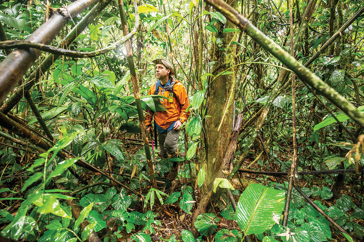
Fisher hikes through the dense Mosquitia jungle. Though the site of the City of the Jaguar is only 10 kilometers from the nearest cleared area, it’s so difficult to reach that Fisher says it “might as well be on the moon.”
• • •
The 10 kilometers of jungle that separate the City of the Jaguar from the nearest deforestation are so difficult to pass that it “might as well be on the moon,” Fisher says, but he knows that the jungle won’t be a barrier forever. The team worked quickly to document, stabilize, and curate the site before leaving it in the hands of Honduran authorities. He won’t return — it’s too remote and too dangerous.
“I’m going to stick with working in Mexico for a while,” Fisher says. “I love archaeology, but I’m not going to die for it.”
But the expeditions to the Mosquitia did more than establish the location of a new archaeological site.
The attention moved the Honduran government to protect the archaeological site and to protect the forest that surrounds it. “We think that without these protections, it would be deforested in a decade or less,” says Fisher. “Maybe for just a few years, we actually are responsible for helping to save parts of the remaining Mosquitia tropical forest.”
Second, and perhaps more important, it confirmed the potential of LiDAR. Fisher is increasingly concerned about the rapidity with which the world is losing its archaeological heritage. There may be many sites like the City of the Jaguar that are currently unknown, and which could easily be destroyed by the spread of agriculture and urbanization. These scans offer an opportunity to document the remains of the ancient world before they’re lost forever.
“I came up doing fieldwork. I love fieldwork. It’s the life blood of an archaeologist,” he says. “But we’re losing so much archaeology — really cultural and ecological patrimony is the way that I usually phrase it. The world is endangered in a way that it never has been. There’s an argument that we should leave our boots in the closet and just scan, scan, scan. Create baseline data of what we’re losing before it’s too late.”
John Allen is the associate publisher for On Wisconsin.
Published in the Fall 2017 issue


Comments
No comments posted yet.