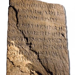
Letters: Way to Rune a Hypothesis
“Rune with a View” [Spring 2012] raises some interesting questions about the Vikings coming to mid-America: In boats propelled by sails and oars, how did they travel up the St. Lawrence River against the wind and the current?
What did they do to get by the numerous rapids on the river that today are bypassed by canals? What did they do when confronted by Niagara Falls and the regional escarpment over which it flows? How did they get from Lake Huron to Lake Superior in a time long before the Sault Sainte Marie locks?
How did they survive a one-thousand-mile journey through hostile Indian territory?If they really did penetrate North America, why is this feat not recorded in their sagas, which proclaim their history?
Marilyn Hurst MS’85, PhD’91 Madison
Published in the Summer 2012 issue

Comments
Budd Adams June 14, 2012
Though the Vikings left no journal, the difficulties you listed are fairly minor compared to those overcome by Lewis and Clark, so I’d not question their ability to make the St. Laurence Great Lakes trip. Take a look at Undaunted Courage by Stephen Ambrose for a prize winning account of the 1803-6 continental crossing.
Eric Van Swearingen July 16, 2014
There is a theory I haven’t seen entertained as of yet. The stones I believe are navigational pinpoints or journals to global locations. All the stones located in Oklahoma have the same date, but different years. This date was accepted as simply an important Viking holiday. I disagree.
Stonehenge was originally a cemetery with a circular tombstone configuration. I believe the vikings came across the site centuries later and realized its usefulness for observing and measuring solar movements. Then, later realized with more stones placed in sequence, they could map stars and calculate the exact length of one year. Given a particular date, stars and or the sun viewed from anywhere on the globe, could be charted, mapped, recorded and compared with their home base (Stonehenge). With a stone left at a location depicting a description of travels and the date of placement, the vikings could more easily chart travels across the globe with precise locations of those travels along with the ability of returning to that exact location if they were lucky enough to make it home with their log journals. Basically, using the same date over and over each year as they moved across a land mass allowed them to navigate land similar to how they were already navigating the seas.
Not only could they later calculate their global positions, but if they were traveling across a large unknown landmass such as the Americas, they could use the stones as a bread crumb trail to move back the way they came if they became lost. By repositioning themselves on their chosen date to the configuration they had charted, they could more easily find their way back to their ships hidden along a beach, years later.
Stonehenge’s location is a convenient location relative to the known world. Charting stars from Scandanavia would have offered a completely different vantage from that of Oklahoma. Stonehenge’s latitude is close to the area the Vikings seemed to be traveling towards as they moved northward from the Gulf of Mexico, thus creating an optimal scenario for charting their navigation.
The Vikings fought fearlessly over and over for the area of England containing Stonehenge. Without that navigational “hub” their world explorations were worthless if that was in fact what it actually was. Who knows, but an interesting take none the less.